Diesen Artikel auf Deutsch lesen 🇩🇪
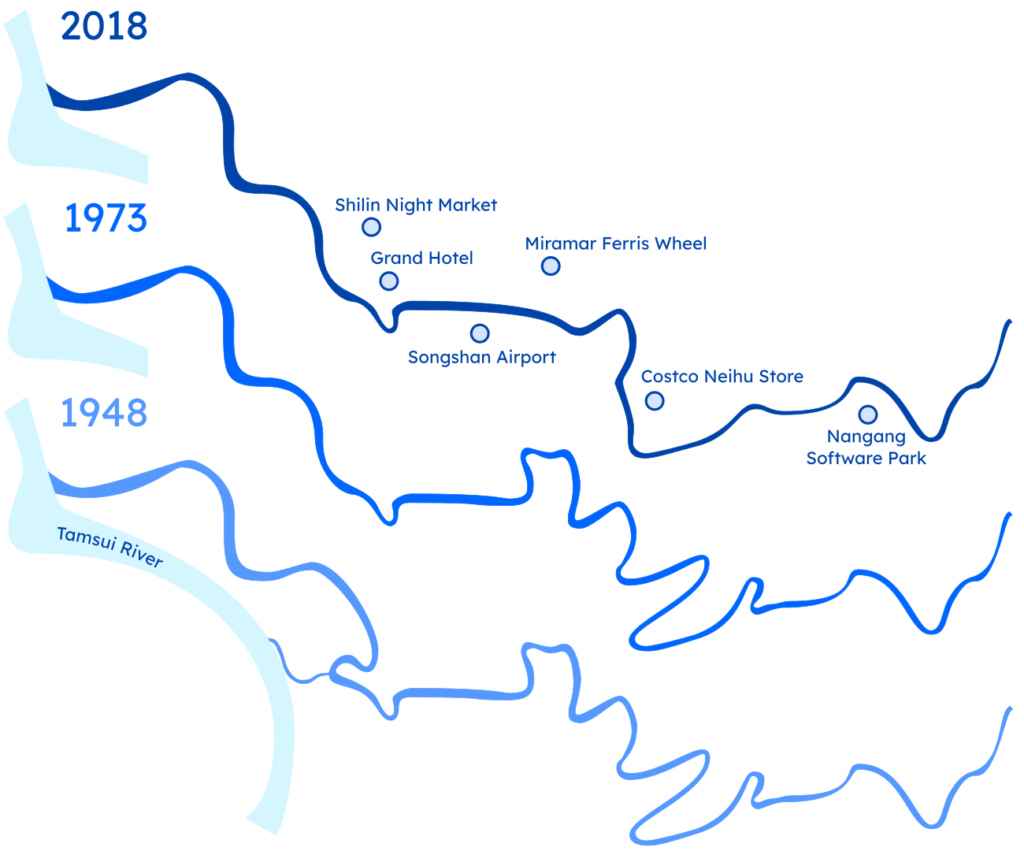
When you look at the Keelung River in Taipei today, everything appears normal and unremarkable. However, those who have lived in Taipei for a long time might remember that the river once had a very different course. As someone relatively new to the city, I always thought the Keelung River looked as it should. It wasn’t until I studied historical maps and aerial images that I discovered the river’s significant changes. Further research revealed two major alterations to the river’s course in the 1960s and 1990s, which transformed the districts of Shilin (士林), Dazhi (大直), and Neihu (內湖) into what we know today. In fact, much of Dazhi and Neihu owes its existence to these river modifications.
The First Phase of River Straightening
The first river straightening took place from November 5, 1964, to July 19, 1965. Over nine months, the river section in Shilin was shifted approximately 500 meters westward. Originally, the river turned northward at the Grand Hotel towards Jiantan, then northwest near the Shilin Night Market, and finally westward near what is now the Taipei Children’s Amusement Park before rejoining its existing riverbed.
(click on image for a larger view)
The abandoned meander was preserved as an oxbow lake until the 1980s, when it was filled in, and new buildings were constructed. Today, the old river course is still discernible in the layout of the streets. Shishang Road (士商路) and the parallel Jihe Road (基河路) follow the former riverbanks. Interestingly, the Chinese name of Jihe Road, 基河路, derives from “Jilong He” (基隆河), the Chinese name for the Keelung River.


The Second Phase of River Straightening
The second phase, which had the most significant impact on the city, occurred from November 11, 1991, to November 10, 1993. During this time, two large meanders in Dazhi and Neihu were cut off, shortening the river by 6 km. Unlike the first straightening in the 1960s, where the abandoned meander was left as a lake, these meanders were immediately filled in and developed, forming much of the Dazhi and Neihu districts.
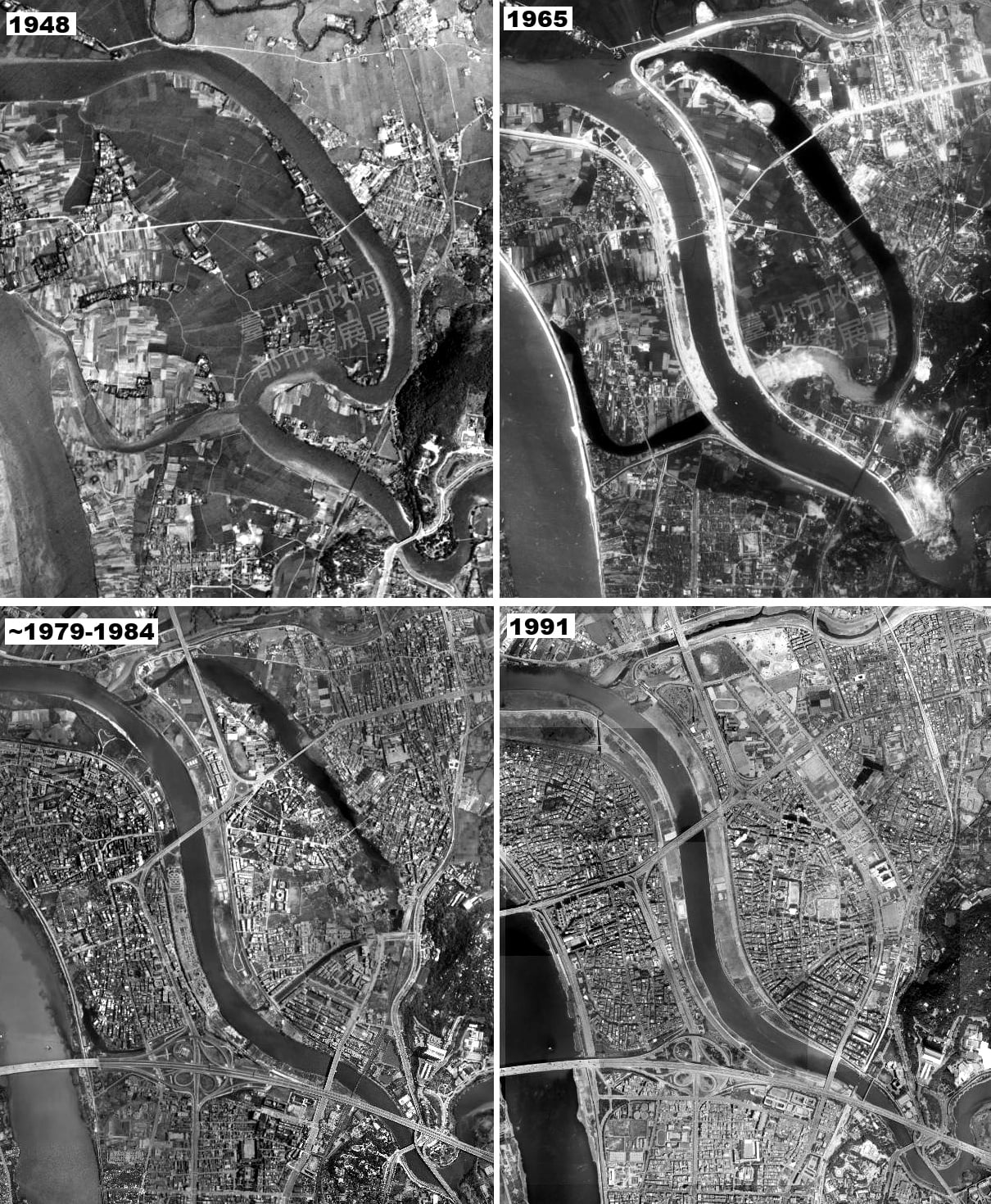
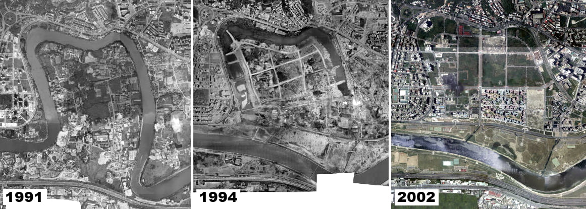
River Straightening in Dazhi
Aerial images reveal the straightening of the Keelung River in the Dazhi section. In 1991, the river still followed its original course, making a large meander northward almost to the foot of Jiannan Mountain (劍南山). By 1994, the new riverbed was established, and the old meander was partially filled and developed. By 2002, the old meander was barely visible, with only Mingshui Road (明水路) and Tiding Boulevard (堤頂大道) tracing the former riverbanks.
(click on image for a larger view)


River Straightening in Neihu
In Neihu, two meanders were cut off during the river straightening. In 1992, the larger meander, which extended 1.5 km to the east, was removed. The smaller meander, located in Nangang (南港) north of Kunyang (昆陽), was eliminated in 1993. Like in Dazhi, aerial images from 1993 and 2002 show that the old meanders were swiftly filled in and developed.

(click on image for a larger view)
Today, the old meanders are barely recognizable in Neihu’s street network. Only Xingshan Road (行善路) partially follows the path of the larger meander, while the smaller meander has disappeared entirely.


Keelung River Straightening to Mitigate Flood Risk
Historically, Taipei was frequently plagued by floods from the rivers within the basin. In 1963, Typhoon Gloria caused severe flooding in low-lying areas of Taipei and New Taipei, with water levels standing at two meters for nearly two days. This flood caused extensive damage to agricultural areas in the floodplains.
Until then, traditional flood protection methods such as dikes and washlands—areas that could be deliberately flooded—were used. However, another major flood in 1985, caused by Typhoon Nelson, led to the decision to implement more radical flood prevention measures.
The straightening of the Keelung River in Dazhi, Neihu, and Nangang was expected to allow floodwaters to flow more quickly, reducing the risk of flooding in these areas. A positive side effect was that the newly reclaimed land could be used for urban development. The tight meanders of the Keelung River had been a hindrance to the city’s expansion.
However, river straightening was controversial. Many residents were forced to relocate, and the ecological impact on the river was significant. Additionally, the faster-flowing water increased the risk of flooding downstream, where the river had not been straightened. In Taipei, this risk is somewhat mitigated by the fact that the Keelung River flows into the much larger Tamsui River, which quickly carries the water into the Taiwan Strait.
To further enhance flood prevention in Taipei, the Yuanshanzi Flood Channel (員山子分洪道) was constructed between 2003 and 2005. This channel, actually a tunnel, is located in the upper reaches of the Keelung River in Ruifang and connects the river directly to the ocean. In times of heavy rainfall, excess water from the mountain areas can be diverted straight to the sea, bypassing Taipei. Since its completion, the Yuanshanzi Flood Channel has proven to be highly effective, protecting Taipei from floods on numerous occasions.
Further reading
For those who want to learn more about the history of Taipei and the rivers, I recommend these articles as a starting point:
“Taiwan in Time: Cutting out the river bends”
And for those who like historical maps and want to explore Taipei’s past:
Historic maps and aerial images of Taipei from the Japanese era until today
Discover old Taipei – Taipei Historical Maps App
Titel image by Janet Chen from Pixabay
If you like this content and don’t want to miss new blog posts, consider subscribing to our newsletter!